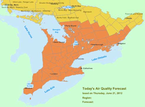
This is an update to my previous blog Smog Alert: Southern, Central & Parts of Northern and Eastern Ontario June 20, 2012.
Effective immediately, the Ontario Ministry of the Environment in Canada has lifted the Smog Advisory (June 20, 2012) for the following forecast regions because increasing wind speeds ahead of a cold front are allowing for good mixing and dispersion of pollutants, resulting in cleaner air in the air quality forecast regions listed as follows:
- Burk’s Falls-Bayfield Inlet
- Elliot Lake-Ranger Lake
- Greater Sudbury and Vicinity
- Manitoulin-Northshore-Killarney
- North Bay-West Nipissing

However, a Smog Advisory remains in effect for:
- Bancroft-Bon Echo
- Barrie-Orillia-Midland
- Belleville-Quinte-Northumberland
- Brockville-Leeds and Grenville
- City of Hamilton
- City of Toronto
- Dufferin-Innisfil
- Dunnville-Caledonia-Haldimand
- Elgin
- Grey-Bruce
- Haliburton
- Halton-Peel
- Huron-Perth
- Kingston-Prince Edward
- London-Middlesex
- Niagara
- Oxford-Brant
- Parry Sound-Muskoka-Huntsville
- Peterborough-Kawartha Lakes
- Sarnia-Lambton
- Simcoe-Delhi-Norfolk
- Stirling-Tweed-South Frontenac
- Waterloo-Wellington
- Windsor-Essex-Chatham-Kent
- York-Durham
Hot, sunny conditions, combined with a southwesterly flow of polluted air from the U.S. and local build-up of pollutants are resulting in elevated smog levels across southern, central, and parts of eastern Ontario.
This advisory will remain in effect until further notice.
The details of the smog forecast for these affected regions are as follows:
- During Thursday, June 21:
- Currently, a high pressure ridge is over the eastern US
- A low pressure system is over northwestern Ontario with a cold front stretching southward from the low across Lake Superior
- The front is forecasted to move slowly eastward across northern Ontario this morning, and southern Ontario this afternoon and evening
- Cloudiness and showers are forecasted in the vicinity of the front, with hot and sunny conditions and southwesterly winds are ahead of the front, and clean northerly winds behind the front
- Air quality indices are forecasted to:
- increase to the poor category in the smog advisory regions due to ozone
- be in the good to moderate categories elsewhere
- During Friday, June 22, and Saturday, June 23:
- The cold front is forecasted to be east of the province
- A high pressure system is forecasted to move towards the Great Lakes
- Generally seasonable temperatures are forecasted with partly or mostly sunny skies and west to northwesterly winds
- During Friday, air quality indices are forecasted to be:
- in the good to moderate categories in southwestern Ontario,
- generally in the good category elsewhere
- On Saturday, good to moderate air quality is expected across the province.
For more information:
- Check out the Air Quality Index or AQI in your area.
- To help combat smog, here’s what you can do to spare the air.
- Learn more about air quality.
———————————
You may also want to know:
