This video presents Planning for the Relief Line.
- The City of Toronto and the Toronto Transit Commission (TTC) are planning for the “Relief Line”, a future rapid transit line that would connect downtown Toronto to the Bloor-Danforth Subway east of the Don River.
- It will assist in relieving crowding on the Yonge Subway line and the Bloor-Yonge interchange station as well as provide riders with more travel options.
The Relief Line is a new rapid transit line that would connect Line 1 Yonge-University in downtown Toronto to Line 2 Bloor-Danforth east of the Don River in Toronto, Ontario, Canada .
“The City, TTC and Metrolinx have identified capacity issues bringing people to and from work in the downtown core. Union Station and the Bloor-Yonge interchange currently experience extreme congestion at times, and even with planned operational and equipment improvements, both will be over capacity in the next 15 years or so. A new rapid transit line is an option to provide relief to both Bloor/Yonge and Union Stations to help maintain access into downtown.“
The City of Toronto, in collaboration with TTC and Metrolinx, are studying options for a new rapid transit line connecting the Yonge-University-Spadina Subway downtown, travelling east and north to meet the Bloor-Danforth Subway somewhere between Broadview and Coxwell.
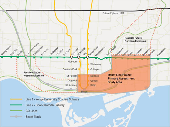
- The eastern section of the Relief Line between Downtown and the Bloor-Danforth Subway east of the Don River would provide the greatest and most immediate impact to relieving overcrowding on the Yonge Subway.
- Riders west of Yonge Street already have the option of the University line to travel into the downtown.
- The first phase of the proposed new line would offer the same service to riders from the east and north, including East York, Scarborough, and parts of North York and the former City of Toronto.
- Potential future phases of the Relief Line can include extensions west from the central business district to Bloor-Danforth Subway somewhere between Lansdowne and Keele as well as North from the Bloor-Danforth Subway to the Eglinton Crosstown LRT in the vicinity of Don Mills Road. These extensions have not yet been studied.
The City and TTC are specifically looking for feedback at this time on:
- potential station area options between downtown and the Danforth, east of the Don River, and
- evaluation criteria that will be used to determine the preferred route and station locations.
You will have the opportunity to learn more about the study and provide feedback at the following identical public meetings:
Monday, March 9, 2015
St. Lawrence Hall
157 King Street East, Toronto, ON
TTC: King Station or 504 Streetcar
Time: 7:00 p.m. – 9:00 p.m.
Thursday, March 12, 2015
Christ Church Deer Park
1570 Yonge Street, Toronto, ON
TTC: St. Clair Station
Time: 7:00 p.m. – 9:00 p.m.
City Planning is conducting an integrated assessment of the Relief Line, the Scarborough Subway Extension and SmartTrack.
- Throughout 2015, analysis and public consultation for these projects will be co-ordinated for recommendations to City Council.
Please click here for more info.
NEWS RELEASE
March 2, 2015
City of Toronto and TTC seeking public input on potential station locations for relief line
The City of Toronto’s City Planning division, together with the Toronto Transit Commission (TTC), is planning the Relief Line – a new rapid transit line that would connect Line 1 Yonge-University in downtown Toronto to Line 2 Bloor-Danforth east of the Don River.
The next phase of the study is underway. Members of the public are encouraged to visit http://www.reliefline.ca to review study materials and provide input on the following:
• potential station area options between downtown and the Danforth, east of the Don River, and
• evaluation criteria that will be used to determine the preferred route and station locations.
Four identical public meetings are being held where the public can review study materials, speak directly with the study team and provide input. All meetings are from 7 to 9 p.m.
– Tuesday, March 3 at Calvary Church, 746 Pape Ave.
– Thursday, March 5 at Riverdale Collegiate Institute, 1094 Gerrard St. E.
– Monday, March 9 at St. Lawrence Hall, 157 King St. E.
– Thursday, March 12 at Christ Church Deer Park, 1570 Yonge St.
The Yonge subway is currently over-capacity south of Bloor-Yonge station and passenger transfer between the Bloor-Danforth subway and the Yonge subway is seriously constrained. Even with planned and funded improvements to Line 1, additional transit capacity will be needed to accommodate projected growth. The proposed Relief Line would provide an alternative transit route to downtown from the east and north, and relieve crowding on Line 1 at Yonge-Bloor station and on downtown surface transit routes.
City Planning is conducting an integrated assessment of the Relief Line, the Scarborough Subway Extension and SmartTrack. Throughout 2015, analysis and public consultation for these projects will be co-ordinated for recommendations to City Council.
Information is available at reliefline.ca (http://www.reliefline.ca) and on Twitter by following @CityPlanTO.
This news release is also available on the City’s website: http://bit.ly/1wEJhpI
Toronto is Canada’s largest city, the fourth largest in North America, and home to a diverse population of about 2.8 million people. It is a global centre for business, finance, arts and culture and is consistently ranked one of the world’s most livable cities. Toronto is proud to be the Host City for the 2015 Pan American and Parapan American Games. For information on non-emergency City services and programs, Toronto residents, businesses and visitors can visit http://www.toronto.ca, call 311, 24 hours a day, 7 days a week, or follow us @TorontoComms.
——————————————————–
You may also want to know:
- You’re Invited: Leica Store Bellevue Grand Opening Mar.13-15, Washington + Walking Tours for Leica M & Leica T Cameras Mar.13 & 14, 2015 (FREE Admissions; RSVP required as space is limited)
- Please Help Create the World’s Largest Marine Sanctuary in the Pacific: Petition Before Aug.11, 2014
- McAfee: Superstar Soccer Players’ Screensavers and “Skills” Video Downloads are Risky to Search for Online (McAfee’s FREE SiteAdvisor)
- You’re Invited: “Toronto Observed Through Three Generations: Photographs by Harry Joy, Doug Hemmy and Andy Brooks” Jan.24-May 9, 2015 (Opening Reception Jan.24; FREE Admissions, Toronto)
- Finalists of 2015 Scotiabank Photography Award, the Most Prestigious Award in Canadian Contemporary Photography + You’re Invited to Mark Ruwedel Exhibition Apr.29-Jun.28, 2015 (FREE Admission, Toronto)
- “Benoit Aquin: Mégantic in Pictures”: A Contemporary Photography Exhibition in Montreal February 18 – May 24, 2015 (FREE Admission for ages 12 and under, and VIP members)
- “Eyes Wide Open! 100 Years of Leica Photography”: The Anniversary Exhibition in The Fotografie Forum Frankfurt 13 March – 31 May, 2015 (Germany; FREE Admission for children aged under 12 and members; Reduced admission for students, apprentices, unemployed persons, severely handicapped persons)
- You’re Invited: Camera Obscura at The Photographers’ Gallery (FREE admission in London, UK)
- Panasonic + UNESCO: Beautiful 2015 World Heritage Calendar App for PCs & Tablets in Five Languages (FREE App)
- Stratasys’ New Recycling Program of 3D Printing Material Canisters & Cartridges for North American Customers Starts Today: Waste Disposal at No Charge (FREE disposal & recycling program)
- Photography Copyright Kit (FREE)
- Olympus ‘Anywhere Classroom’ Video Series Starts June 26, 2014: An Online FREE Photography Class Using Olympus OM-D Cameras & Lenses
- Nikon Canada Invites Canadian Residents to Nikon Image Space: An Online Service for Sharing Photos or Recording Memories (FREE online service for all Canadian residents to share & record images: FREE two GB of storage for everyone and Nikon camera owners get an extra FREE 18 GB of storage.)
- New NIKON IMAGE SPACE App Renewal at No Charge: Benefits Include Seeing Images Larger & Browsing Images Stored on Your Smart Device (FREE online photo sharing service + FREE renewal of smart device app for “NIKON IMAGE SPACE”)
- Canon’s Cloud-based Image Management Service, irista: No Cost for Up to 15GB + New Updates are Now Live (FREE 15GB of cloud storage space with full irista functionality)
- You’re Invited to the New Leica Fotopark: A Photo Platform for Passionate Photographers to Discover, Exchange, Organise, Create [Registration on www.leica-fotopark is FREE, as is the use of the platform for data volumes of up to ten gigabytes (GB)]
- You’re Invited: Download Leica Fotografie International App for iPhone, iPod Touch, iPad and Android
- Scarborough Subway Project Assessment-Line 2 Extension: Public Consultations Jan.31 & Feb.2, 2015 + Online Feedback
- Celebrate: Fort York Visitor Centre (five new exhibitions is opened inside the new Visitor Centre in 2014 – 2015)