The following silent video presents “Eglinton Connects: Demonstration of how the Golden Mile could transform over time.”
- VIDEO IS SILENT.
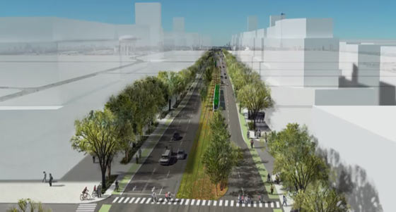
- “This video shows a section of the Eglinton streetscape near the Golden Mile by Warden Avenue” in Toronto, Ontario, Canada.
- “The Crosstown Light Rail Transit (LRT) infrastructure, which will be running at grade along the street at this section, offers the potential for positive incremental change to the street itself, as well as development potential of adjacent lands.”
- The video depicts a demonstration of how this could happen.
- “First, the LRT is built, running down the centre of the street, and replacing the bus lanes that currently exist.
- The LRT could run along a planted green surface, lined with trees.
- New bike lanes approved in 2010 could be improved by being physically separated from moving traffic.
- Over time, the public realm could be transformed through wider sidewalks and space for large trees.
- With an improved public realm and THE new LRT, development may be attracted to the area and start building along the line.
- New development would bring new people and jobs to the area, to help maximize the new LRT infrastructure.”
- “An improved public realm and transit supportive development are goals of the City of Toronto’s Eglinton Connects Planning Study. “
“The Vision
Eglinton Avenue will become Toronto’s central east-west avenue – a green, beautiful linear space that supports residential living, employment, retail and public uses in a setting of community vibrancy. Its design will balance all forms of mobility and connect neighbourhoods and natural valley systems to the larger city and the region.”
Eglinton Connects: City of Toronto Planning Study
Executive Summary, March 2014
http://www1.toronto.ca/City%20Of%20Toronto/City%20Planning/Urban%20Design/Eglinton%20Connects/Apri14%20Update/EgConnects%20ExecSum%20Final.pdf
Eglinton Connects is about planning for the future Eglinton Avenue, and how to best leverage investment in rapid transit for the benefit of communities in Toronto.
- Metrolinx is investing in the design and construction of the Eglinton Crosstown LRT line.
- This investment will result in improvements to public transit service along Eglinton Avenue over the next decade.
This is an update to these previous blogs:
The Plan
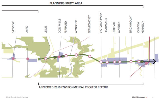
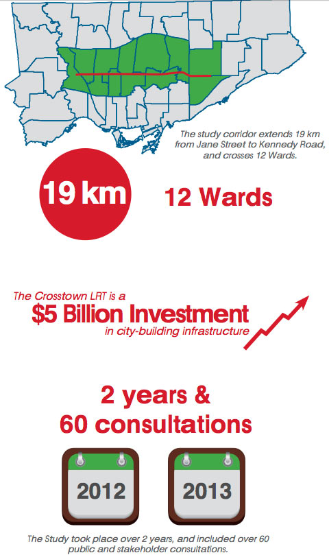
EGLINTONconnects is the City of Toronto’s comprehensive planning study for developing a vision and planning recommendations for the future of Eglinton from Jane Street to Kennedy Road.
- The Plan included a Municipal Class Environmental Assessment (EA) to guide reconfiguration of the Eglinton right-of-way where the Crosstown LRT will run underground.
- “Eglinton Avenue can become a green public realm that connects seamlessly into the Humber and Don River valleys, including greater tree canopy, enhanced open spaces and green transit infrastructure.”
The Process
The EGLINTONconnects Plan is the result of a two-year process involving more than 60 public and stakeholder consultation events and four surveys.
- Approximately 5,000 people participated in the study.
Eglinton Scarborough Crosstown Planning Study Team addresses some concerns and provides an update in the following letter:
“Facts about Eglinton Connects
City Planning has received comments, questions, and phone calls from residents and concerned citizens about Eglinton Connects. The nature of some of these calls is concerning, as several of them reference misleading or incorrect information. For more than 2 years, the Planning Study Team has worked to involve you in the process and keep you informed about goings-on and how you can get involved. Today, we are writing you to make sure you have the right information.
Below are some of the common questions City Planning has received in the last two days regarding Eglinton Connects. As always, more information is available at www.toronto.ca/eglinton.
What components of the Eglinton Connects Planning Study are before Council July 8-9?
Official Plan Amendments and Site and Area Specific Policies are before Council today or tomorrow. These amendments set the tone for further study in the Focus Areas, set out where laneways will be required over the long term through new development, and propose changes to land use designations. The full Staff report is available here. This information was previously sent to you via an e-update from the Study Team on June 16, 2014.
The streetscape plan (the plan for how the street will look, how it will function, the width of sidewalks, street trees, bike lanes, etc) was passed unanimously by Council on May 6, 2014.
Through Eglinton Connects, will all of Eglinton Avenue have only 1 travel lane in each direction?
No. The corridor is 19km long and for 11km the LRT will be underground. For this portion (roughly from Black Creek Drive to Brentcliffe Road), an Environmental Assessment was conducted as part of Eglinton Connects, and it was approved at Council on May 6, 2014. This Environmental Assessment generally tailored the street to the local conditions, but most of the future roadway will be four lanes, with turn lanes at selected intersections. However, a 3 lane cross section was approved for about 1.5km of the corridor, roughly between Avenue Road and Mount Pleasant. This means one lane in each direction for continuous traffic flow, plus centre lane for turning movements as well as permanent parking in indented bays. For more information on this, download the Staff Report, or visit the ‘Questions’ section of the website (Materials > Questions > Transportation Study FAQs).
Are houses going to be expropriated to create laneways?
No. New laneways or laneway widenings will occur only through redevelopment and will be placed within the 7.5m. setback distance between a future building fronting Eglinton and their rear property line. The intention of laneways is to create a great street on Eglinton by providing a place for loading and servicing to take place at the back of the building, rather than the front.
Are laneways intended to act as arterials for Eglinton or otherwise accommodate through traffic?
No. Laneways will be designed for local servicing and access only.
Are houses to be demolished to encourage new development?
No. However, on 2 properties (6 Sanderstead Avenue, and 9 Croham Road), an Official Plan Amendment is being put forth as a ‘test’ or ‘demonstration’ that would allow for a developer to purchase the home (if the owner is willing to sell), and use the home for a laneway, landscaping, or parking. This would allow the property fronting on Eglinton Avenue to be built taller closer to Eglinton, and transition down in scale to the neighbourhood in behind.
Links to all Staff Reports and Committee or Council Decisions are on the website under Materials > Staff Reports.
Thank you once again for your involvement and participation in the Study. Stay tuned for more updates regarding zoning, which should be coming shortly.
Regards,
The Eglinton Connects Planning Study Team”
Contact Info:
| Phone within Toronto city limits: | 311 |
| Phone outside city limits: | 416-392-CITY (2489) |
| TTY customers: | 416-338-0TTY (0889) |
| Fax: | 416-338-0685 |
| E-mail: | 311@toronto.ca |
————————————–
You may also want to know:
- McAfee: Superstar Soccer Players’ Screensavers and “Skills” Video Downloads are Risky to Search for Online (McAfee’s FREE SiteAdvisor)
- Photography Copyright Kit (FREE)
- Olympus ‘Anywhere Classroom’ Video Series Starts June 26, 2014: An Online FREE Photography Class Using Olympus OM-D Cameras & Lenses
- You’re Invited: Camera Obscura at The Photographers’ Gallery (FREE admission)
- You’re Invited to Magnetic North Exhibtion Until July 19, 2014: Photographs, Artifacts & Contemporary Canadian Art of the Arctic (FREE Admission)
- FUJIFILM Canada Announces “Walk in the Park” Tour with the Fuji Guys and L’Expert Fuji 2014 (FREE Admission: Victoria, September 20) *Dates are subject to change
- Five Ways Canadians Acknowledge the Poignant 1940 Photograph “Wait For Me, Daddy” (FREE public unveiling ceremony, festivites and family activities on Saturday, October 4, 2014)
- You’re Invited: Doors Open Ontario May 3 – October 18, 2014 (FREE admission)
- You’re Invited: Download Leica Fotografie International App for iPhone, iPod Touch, iPad and Android
- Union Station Closure Apr.5 – 7 Before 6 A.M.+ Closures of Gardiner Expressway Start Apr.25, 2014 (Toronto, Ontario, Canada)
- Toronto’s Transit Relief Line & Yonge Relief Network Study Consultations Apr.5, 8, 10,12, 2014 (or provide your feedback online)