The Alternative Port Lands Vision, presented to City of Toronto Executive Committee on September 6, 2011, is a silent video showing the transformation of the Toronto Port Lands from a historical time to a futuristic time – about three decades from now:
This video shows Toronto Mayor Rob Ford talking to media reporters in regards to the Port Lands (Sept 21, 2011):
“Over 800 hectares of strategically located land in the heart of Canada’s economic engine – Toronto’s Central Waterfront – are mostly vacant and underused. About 70 per cent of this land is already in public hands.”
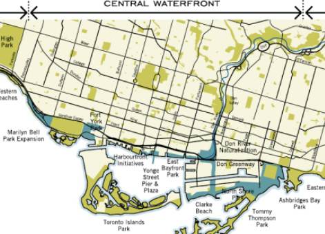
After much ruminations and discussions, the proposed Part II Plan for the Central Waterfront now requires public consultations in order to proceed towards City Council consideration and approval.
“Making Waves: Principles for Building Toronto’s Waterfront” is the proposed Part II Plan for the Central Waterfront, the City of Toronto framework for making Central Waterfront renewal happen.
Central Waterfront Part II Plan, by Paula M. Dill (Commissioner Urban Development Services) and Paul J. Bedford (Chief Planner and Executive Director City Planning Division), 2001 City of Toronto, is organized around four core principles that will steer the renewal of the Central Waterfront. This will be a multi-decade effort.
“CORE PRINCIPLES
Four core principles will act as a framework for the renewal of the Central Waterfront:
- REMOVING BARRIERS/MAKING CONNECTIONSThe waterfront has to feel like and function as part of the city fabric.
The first principle of the Plan relates to the removal of barriers in order to reconnect the city with Lake Ontario.
This is the key to unlocking the potential of Toronto’s waterfront. (One barrier is the above-ground Gardiner Expressway)
- BUILDING A NETWORK OF SPECTACULAR WATERFRONT PARKS AND PUBLIC SPACESThe second principle of the Plan recognizes the significance of the public realm in transforming the Central Waterfront into a destination for international tourism, national celebration and local enjoyment.
Quality public places will distinguish the Central Waterfront as a special place with spectacular waterfront parks and plazas and inviting natural settings that please the eye and capture the spirit.
- PROMOTING A CLEAN AND GREEN ENVIRONMENT
The third principle focuses on achieving a high level of environmental health in the Central Waterfront.A wide variety of environmental strategies will help shape sustainable waterfront communities and showcase the City’s commitment to developing a clean and green waterfront. - CREATING DYNAMIC AND DIVERSE NEW COMMUNITIES
The fourth principle emphasizes the importance of creating dynamic and diverse waterfront communities that are unique places of beauty and offer quality and opportunity for all citizens.New waterfront communities will be acclaimed for their high degree of social, economic, natural and environmental health and cultural vibrancy.
For each principle, the Plan sets out the following “Big Moves” – 23 in all – that will make waves redefining Toronto’s future via central waterfront revitalization:
- A) REMOVING BARRIERS/MAKING CONNECTIONSA1_Once funding for major improvements to the road system and GO Transit/TTC services including Union Station is in place, and once these improvements have been substantially completed, the elevated Gardiner Expressway will be replaced.
A2_A Waterfront Light Rapid Transit line will stretch across the Central Waterfront from Exhibition Place to the Port Lands.
A3_Lake Shore Boulevard will be transformed into a grand waterfront boulevard.
A4_Queens Quay will become a scenic waterfront drive from Bathurst Street to the Port Lands.
A5_The Martin Goodman/Waterfront Trail will be completed through the Central Waterfront and connected to the citywide trail system.
A6_Key cultural and heritage corridors which link the assets of the city with the water’s edge will be promoted and reinforced.
- B) BUILDING A NETWORK OF SPECTACULAR WATERFRONT PARKS AND PUBLIC SPACESB7_A continuous band of green will be reserved along the water’s edge for public use.
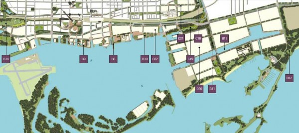
B8_A dramatic new Yonge Street Pier will be built at the foot of Toronto’s historic main street (see the second “Public Realm Map of Port Lands and Don Lands” below).
B9_Harbourfront Centre will become an even stronger draw with a new public plaza between Queens Quay Terminal and York Quay Centre and an integrated nautical centre on John Quay (see the second “Public Realm Map of Port Lands and Don Lands” below).
B10_A bold new East Bayfront Park, reflecting the industrial heritage of the area and anticipating its extraordinary future, will be created (see the first “Public Realm Map of Port Lands and Don Lands” below).
B11_A new green corridor, the Don Greenway, will be developed in the centre of the Port Lands (see the first “Public Realm Map of Port Lands and Don Lands” below).
B12_A new Lake Ontario Park, from Clarke (Cherry) Beach to Balmy Beach, will give Toronto a much-enhanced continuous urban park system (see the first “Public Realm Map of Port Lands and Don Lands” below).
B13_The Ship Channel through the Port Lands will become a powerful focal point around which new mixed-use communities will be built (see the first “Public Realm Map of Port Lands and Don Lands” below).
B14_A new Fort York Park will be larger and more visible, re-establishing the Fort’s status as Toronto’s most significant heritage site (see the second “Public Realm Map of Port Lands and Don Lands” below).
B15_Almost three hectares will be added to Marilyn Bell Park, which will be redesigned and improved as a gateway to the waterfront.
B16_Ontario Place will be woven into the waterfront park system with better access for the public to enjoy its facilities and paid attractions.
- C) PROMOTING A CLEAN AND GREEN ENVIRONMENTC17_Priority for Sustainable Modes of Transportation
A “next generation” transportation system that gives priority to transit, cycling, walking and water transport and reduces the need for car use will form the basis for transportation planning in the Central Waterfront.
Future travel demand will be mainly met by non-auto means.
Road capacity will be added only to meet local traffic needs.
C18_A flood protection berm will be built along the Don River to eliminate flooding problems in the West Don Lands and surrounding neighbourhoods (see the first “Public Realm Map of Port Lands and Don Lands” below).
C19_The mouth of the Don River will be re-routed and renaturalized, thereby improving the ecological function of the river, and providing flood protection and an important open space and recreational link to adjacent parklands (see the first “Public Realm Map of Port Lands and Don Lands” below).
- D) CREATING DYNAMIC AND DIVERSE NEW COMMUNITIESD20_Opening Up the Port Lands to Urban Development (see the first “Public Realm Map of Port Lands and Don Lands” below).
The vast Port Lands will be cleaned up and opened to a range of urban development opportunities including new urban communities, an international convergence district, “green” industries and a rich infrastructure of recreational, cultural and tourist amenities.
The vast Port Lands, an area more than ten times the size of London’s Canary Wharf, will become Toronto’s springboard to the future, a place for wealth creation, originality and creativity in all aspects of living, working and having fun.
The Port Lands will be transformed into a number of new urban districts set amid the hustle and bustle of Toronto’s port activities.
An enticing environment conducive to the creation of an international convergence district for knowledge-based industries, film and new media activities will be nurtured.
The new Port districts will be supported by a rich infrastructure of recreational, cultural and tourist amenities.
Innovative housing including live/work, lofts, and workplaces that appeal to a range of needs…from start-ups to mature international operations.
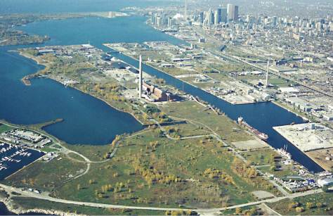
(Above) The Port Lands Represent the Most Significant Opportunity to Revitalize Vacant and Underutilized Land. 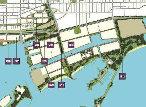
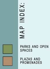
Public Realm Map of Port Lands and Don Lands: from left to right; B10, D22, D21, C19, C18, D20, B11, B13, and B12

D21_A New Beginning for the West Don Lands (see the first “Public Realm Map of Port Lands and Don Lands” above).
A Flood Protection berm will be built along the Don River to eliminate flooding problems in the West Don Lands and surrounding neighbourhoods to the west.
It will also provide naturalized open space and active parkland along its edge for use by the west Don River communities and fulfill a crucial stormwater function.
The adjacent King-Parliament and St. Lawrence will benefit from this increase in active parkland.
The Renaturalizing the Mouth of the Don River:
The mouth of the Don River will be rerouted through lands south of the rail corridor.
This will improve the ecological function of the river, provide flood protection for the Port Lands and East Bayfront and attract new wildlife to the area.
The renaturalized mouth of the river will also become a key open space and recreational link to the Don Valley, West Don Lands, Port Lands and waterfront park system.
This enhanced river setting will provide a gateway for the new urban communities in the Port Lands.
Bridges that carry the new Queen’s Quay and Cherry street over the river mouth will be designed as signature entrances of beauty and inspiration.
With the construction of the flood protection berm and the naturalization of the mouth of the Don River, the west Don Lands will be redeveloped into diverse mixed-use communities.
D22_The East Bayfront will become a prominent waterfront address for working and living (see the first “Public Realm Map of Port Lands and Don Lands” above).
D23_Building on its historical role as a place for celebration and exhibition, Exhibition Place will be expanded into a dynamic area where people work, play, visit and live.
The benefits to the city and the entire GTA (Greater Toronto Area) region will be enormous. Over 40,000 housing units and 35,000 jobs can be generated, all in the core of the city.
The focus of this Part II Plan:
- is 10 Kilometres from Dowling Avenue to Coxwell Avenue,
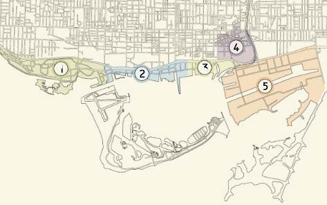
- encompasses Exhibition Place, Ontario Place, Fort York, the existing Bathurst-Strachan, Central Bayfront and Harbourfront neighbourhoods, the East Bayfront, the West Don Lands and the Port Lands
The communities that make up the Central Waterfront are shown on Map Two above. Most of the land capable of accommodating new growth in the central waterfront’s west end (i.e. Exhibition Place) is “clean” land with existing infrastructure.
In the east end, particularly in the West Don Lands and Port Lands, where there is greatest opportunity for change, much of the land needs soil and groundwater remediation and new infrastructure.
Major elements of Central Waterfront Part II Plan include:
- reconfiguration of the Gardiner Expressway corridor in the Central Waterfront;
- substantial upgrades to GO Transit and TTC Services;
- a vastly improved, expanded and accessible public open space system;
- soil and groundwater remediation and flood control
Here are some interesting PRINCIPLES of Central Waterfront Part II Plan:
- (P23) The health and biodiversity of the Central Waterfront will be enhanced and restored by protecting existing wetlands, fish and wildlife habitats, rare plant and animal species, shorelines, beach areas, woodlots and lands designated “Natural Areas” and Environmentally Significant Areas”.
- (P24) Development will contribute to the water quality in Toronto’s rivers and streams, as well as in Toronto Bay, the Outer Harbour and Lake Ontario.
- (P25) Stormwater will be managed as close to its source as possible with end-of-pipe options being a last resort.
- (P26) Combined sewer outfalls that discharge into Lake Ontario, the harbour and rivers and streams will be eliminated.
- (P27) The Central Waterfront will be a model of leading-edge environmental technologies.Alternative sources of generating electricity including co-generation, anaerobic digestion, wind turbines and solar power will be pursued as well as district heating and cooling.
- (P28) The Central Waterfront will showcase successful redevelopment of brownfield sites into sustainable residential and employment areas.When applicable, remediation requirements will be balanced by the need to protect environmentally sensitive areas.
- (P29) Lakefilling will be considered only for stabilizing shorelines, improving open space connections, preventing siltation and improving natural habitats.
- (P30) An expansion of the Ashbridges Bay Sewage Treatment facility will be compatible with future park plans in this area.
- (P39) A mix of housing types, densities and tenures will accomodate a broad range of household sizes, composition, ages and incomes
- (P40) The overall goal of the Central Waterfront is that affordable rental housing and low-end-of-market housing comprise 25 % of all housing units.To the extent possible, and subject to the availability of funding programs and development cross-subsidization, the greatest proportion of this housing will be affordable rental with at least one-quarter in the form of two-bedroom units or larger.
- (P43) The Port Lands will be developed with new media and knowledge-based businesses and “green” industries in addition to maintaining their important role in the city’s economy as a location for downtown-serving and marine-related industries and the Port of Toronto.Large tracts of vacant land, the proximity to downtown, the existing base of film and new media activities, and strategic marketing and planning to attract these businesses will support the emergence of a convergence district in the Port Lands.
Entertainment industries such as music, film and television production will operate alongside the communications, software development, biotechnology and publishing sectors.
- (P44) Large scale, stand-alone retail stores and/or “power centres” are not part of the vision fro the Central Waterfront.New retail development will only be considered within the context of comprehensive precinct development strategies and will be supportive of the other core principles and policies of this Plan.
Retail uses which require large areas of surface parking will not be permitted.
- (P45) Redpath Sugars and other companies that rely on lake access for their operations will remain important maritime industries on the waterfront.
- (P51) Existing heritage buildings and other elements will be protected and improved.Listed and designated heritage buildings will be conserved for creative reuse in their original locations.
For a complete list of Central Waterfront Part II Plan principles, and more info, please visit http://interstratics.com/toronto-portlands-latest/ .
City Council retains authority for the approval of all planning policies, including the Part II Plan, area-specific precinct strategies and the Development Permit By-laws.
The Toronto Waterfront Revitalization Corporation will be responsible for developing a business plan based on the principles, objectives and ideas expressed in this Part II Plan.
Waterfront renewal will be managed as an ongoing phased effort that will carry on for decades, subject to budgeting and program availability.
Toronto’s waterfront stretches 46 kilometres from Marie Curtis Park at the Etobicoke Creek in the west to Rouge Beach Park at the Rouge River in the east. Toronto’s waterfront is part of the watershed of six major rivers and a city-wide park system.
The Plan proposes three land use designations:
- Development Area (allows a wide variety of land uses),
- Existing Use Area (site continues to be governed by existing planning regulations) and
- Parks, Open Space and Public Use Area
NEXT STEPS
Now that the City has released the Central Waterfront Part II Plan, they are eager to hear what the public thinks before it is considered for approval by City Council. The plan will be discussed at a series of local and city-wide public meetings as follows:
- An initial public meeting is being held from 6:30 p.m. to 9:00 p.m. on Monday, December 12 at the Toronto Reference Library, 789 Yonge Street.The meeting will include a summary of the work to date, the goals for the Port Lands initiative and an overview of acceleration opportunities and challenges for development.The meeting will provide the public with an opportunity to ask questions and discuss their goals and ideas for the Port Lands.
- The on-line consultation initiative is expected to launch early in 2012. Also, two rounds of public consultation are planned to be held throughout the city in 2012.
- On January 24, 2012 the City and Waterfront Toronto will provide City Council’s Executive Committee with a report on required funding for the review.
- The final report on the results of the Port Lands review is expected to be completed for the June 2012 City Council meeting.
THE CITY OF TORONTO, PROVINCE OF ONTARIO AND GOVERNMENT OF CANADA ARE COMMITTED TO MAKING THE REVITALIZATION OF TORONTO’S CENTRAL WATERFRONT A REALITY.”
“TELL US WHAT YOU THINK
To obtain a copy of the Plan, ask questions or give us your comments, please contact us in any of the following ways:
e-mail: www.city.toronto.on.ca/waterfront Write: Waterfront Section
Phone: (416) 338-0338 Community Planning – South District
Fax: (416) 392-1330 18th Floor, East Tower, City Hall
100 Queen Street West
Toronto, Ontario M5H 2N2″
Toronto, Ontario, Canada
News Release
WORK UNDERWAY TO CREATE A PLAN TO ACCELERATE DEVELOPMENT IN THE PORT LANDS
Toronto, November 25, 2011 – Waterfront Toronto and the City of Toronto have begun work to create a development and implementation plan for the Port Lands and are inviting members of the public to be part of the process.
The goal of the initiative is to deliver a high-level road map for accelerating development and maximizing the value of the Port Lands as a unique city legacy. The undertaking is the result of Toronto City Council’s September 21 unanimous decision for Waterfront Toronto in conjunction with the City of Toronto to lead a review of the Port Lands and to ensure the process is informed by extensive public consultation.
An initial public meeting is being held from 6:30 p.m. to 9:00 p.m. on Monday December 12 at the Toronto Reference Library, 789 Yonge Street. The meeting will include a summary of the work to date, the goals for the Port Lands initiative and an overview of acceleration opportunities and challenges for development. The meeting will provide the public with an opportunity to ask questions and discuss their goals and ideas for the Port Lands.
“The work being undertaken is an opportunity to seize the full potential of these lands and to deliver development of enduring value and legacy to the people of Toronto,” said Councillor Peter Milczyn, chair of the City’s Planning and Growth Committee. “It is a first step in realizing our joint objective of creating one of the world’s great waterfronts.”
The work is a highly collaborative process. Waterfront Toronto and the City are working closely with Toronto and Region Conservation and seeking input from other agencies such as The Toronto Port Lands Company and the Toronto Port Authority. Stakeholders such as land owners, tenants, port users and sector specific groups are being engaged throughout the process.
Work on the Port Lands acceleration initiative is well underway. A series of technical working groups are examining key issues including land use and design, infrastructure and constructability, and real estate development and financing. Waterfront Toronto has also issued or will be issuing a number of Requests for Proposals to competitively procure the required technical expertise.
“Our intent is to take a fresh and wide-ranging look at the challenges and opportunities of developing the Port Lands, including examining phasing options, higher-value interim uses, and the feasibility of modifying or removing existing constraints,” said Waterfront Toronto President and CEO John Campbell.
The comprehensive undertaking builds on the large body of work delivered to date on the Port Lands and Lower Don Lands and explores new ideas and creative solutions. The project includes:
- Further examining the options for the Don Mouth Naturalization and Port Lands Flood Protection Environmental Assessment (EA) within the EA’s terms of reference, by reviewing costing and exploring options for value enhancements through such things as alternative construction approaches and project phasing, and by increasing the development potential of surrounding lands;
- Identifying financial and policy tools, incentives, and delivery mechanisms that enable development and offset or reduce the initial public sector investment needed to provide required infrastructure such as roads, services, utilities and flood protection;
- Exploring opportunities to increase private sector investment involvement; and
- Ensuring that the plan delivers a great waterfront for people to live, work and play.
Public consultation will play a central role in the creation of the go forward plan for the Port Lands and will include traditional in-person public meetings and interactive social media and/or web enabled consultations. The on-line consultation initiative is expected to launch early in 2012. In addition to the December 12 meeting, two rounds of public consultation are planned to be held throughout the city in 2012.
The final report on the results of the Port Lands review is expected to be completed for the June 2012 City Council meeting. On January 24, 2012 the City and Waterfront Toronto will provide City Council’s Executive Committee with a report on required funding for the review.
The Governments of Canada and Ontario and the City of Toronto created Waterfront Toronto to oversee and lead the renewal of Toronto’s waterfront. Public accessibility, design excellence, sustainable development, economic development and fiscal sustainability are the key drivers of waterfront revitalization.
Toronto is Canada’s largest city and sixth largest government, and home to a diverse population of about 2.7 million people. Toronto’s government is dedicated to delivering customer service excellence, creating a transparent and accountable government, reducing the size and cost of government and building a transportation city. For information on non-emergency City services and programs, Toronto residents, businesses and visitors can dial 311, 24 hours a day, 7 days a week.
——————————————
You may also like:
